
URBAN
SYNAPSE.
p l a n n i n g | a r t | g a l l e r y
URBAN SYNAPSE.
urban planning office
Cultural and Leisure District

>
The chosen site has been, up until 1965, a green area housing leisure and sporting activities, specific to a waterfront and beach area.
The year 1965 meant the beginning of the communist urban restructuring of the city, which meant building the chemical plant and other large industrial areas on the island
Severe pollution has led to the complete destruction of the natural elements on the island and thus to the disappearing of the leisure activities that were present here.
After an intense period of industrialisation, these plants and other industrial buildings in the study area have shut down, leaving behind large brownfield sites.
One of the reasons for which we chose the theme „Cultural and Leisure District”, is that this tendency to use culture as a development tool has been used continuously throughout the world (especially after the globalization phenomenon) to restructure and redevelop underprivileged areas in the proximity of city centers. Furthermore, projects that have the purpose of restructuring and developing „Brownfield” areas next to city centers and waterfronts are being developed worldwide.
In addition, given the context in which Giurgiu is located (Danube as an important European axis, proximity to Bucharest, the border area between Romania and Bulgaria, the presence of large brownfield sites on the Danube), such an urban restructuring project is one of the best methods to boost the city economically, culturally and attract tourist activity, thus connecting it with the most important element present here, the Danube.
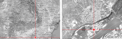
The new proposed urban axis aims mainly to reconnect The Danube with the city of Giurgiu. Therefore, it has a specific shape (elongated in the direction N-S) and an urban pattern which amplifies this direction. In addition, by restoring the former Veriga water canal (which used to connect the St. George channel to the Danube before 1890) on the same NS direction, the city's waterfront has expanded considerably, and with it, the potential to develop this axis and its waterfront.
Structuring the project in relation with the chosen site meant an attempt to identify a real planning method and a bold vision for the area and for its transformation.
By applying a set of planning principles, but also through innovation, the project tried to completely transform and restructure the former industrial areas, by replacing them with a cultural and leisure district, which is incorporated into a new urban tissue having the characteristics of a new city center.
The new development aims to insert here a type of urban pattern that the city does not yet posses, namely a central area that revolves around the Danube, and thus results in a specific type of waterfront development, leading to the birth of a district that will generate strong regional interest.
But another key element that decisively influenced the urban design process was that of water. The Danube and the new proposed channel have played a key role in forming the new urban structure. The Veriga canal and the extended gulf are, for the whole island of Ramadan, the backbone which can support a strong urban development in relation with the element of water.
The importance of the site in the connection between the city and the Danube, but also the high cost of implementation have lead to the proposal of a medium to high urban density, in order to use the land efficiently.
In shaping the new overall urban image, I had to take into account many factors involved directly in the visual impact of the urban environment on users. Because the urban image is not a process which can take place independently, it has to be considered from the very first drafts of the planning process.
Thus, every element existing in this project participates in the defining of the urban image, from the layout of streets, shape, orientation and gauge buildings, the natural geography of the land to different sizes of vegetation used and the materials used for buildings and public spaces.
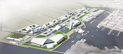
The Masterplan proposes a mixed land-use area, having water as the main structuring element. Also it contains residential areas, office areas, leisure and retail areas.
But the essential uses that are meant to activate the waterfront are the cultural and leisure activities (The Museum of Natural Science and History, the Aquarium Science Center and the Danube Arena).
The project tried to define a mixed-use urban area. This mixed-use will show how the residential activities play a big part in creating a livable central area, and will generate a variety of jobs and opportunities in areas such as trade, culture, leisure and tourism.
Only such a mixed-use district will be able to attract both the activities mentioned above (and with their emergence, will attract tourists) and new residents who will be a part of the economic development, but who will also animate the area regardless of the time of day.
Mixed use also has the role of bringing activities and people in the area during the day, but also during the night. This aspect plays an essential role in the defining of a new urban district, because it increases public safety, lowers crime rate, and last but not least, it will populate and animate the area for a longer period of time than a mono-functional district ever could.
Project name/ Cultural and Leisure District
project location/ Giurgiu city, Giurgiu county
project type/ urban design - urban renewal, Study project
size/ 72 ha
year/ 2010
office/ Urban Synapse
Proiect participant la concursul internațional de arhitectură durabilă ”Holcim Awards 2011”
Secțiunea Next Generation

 |  |  |
|---|---|---|
 |  |  |
 |  |  |
 |  |  |
 |  |  |
 |  |  |
 |  |  |
 |  |  |